LMIG Program Provides Funding Repave City Streets
 The City of Valdosta will resurface 50 city streets (5.12 miles) using funds provided by the Georgia Department of Transportation (GDOT) Local Maintenance and Improvement Grant (LMIG), beginning this spring.
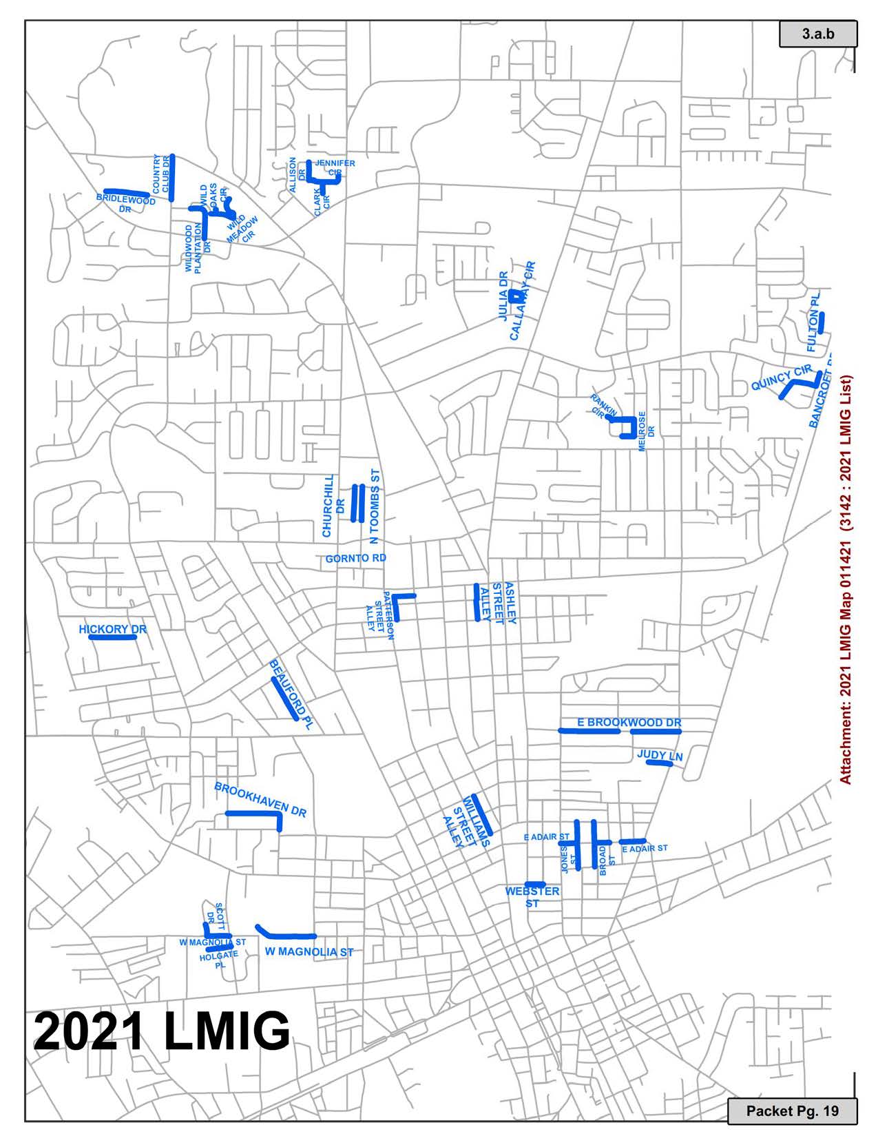
The LMIG transportation funding is allocated from the state based on a formula that includes population and street mileage. The city submitted a list of streets for resurfacing to GDOT for their review, and 50 portions of city streets were prioritized for this year’s LMIG program based on funding availability and conditions of the roads.
The city has successfully used LMIG funds in the past to repave streets and to provide smoother and safer travel for motorists throughout the city.
Streets may be closed for a short duration during the day while under construction, but they will be opened by the end of each working day. Motorists are urged to follow all traffic warning signs and proceed around these construction sites with caution.
- Bancroft Road (from Quincy Cir to Northside Dr)
- Quincy Circle (from Bancroft Rd to Pershing Pl)
- Brookwood Drive (from N Troup St to Deeb Dr)
- Brookwood Drive (from E Ann St to N Forrest St)
- Judy Lane (from West End to N Forrest St)
- Broad Street (from Cypress St to East Gordon St)
- Jones Street (from Cypress St to East Cordon St)
- Adair Street (from N Troup S to N Forrest St)
- Webster Street (from N Lee St to Charlton St)
- William Street Alley (from E Gordon St to E Mary St)
- Holgate Place (from West End to Dunwoody Dr)
- Holgate Place (from Dunwoody Dr to Hightower St)
- Scott Drive (from W Magnolia St to Tracy Ln)
- Magnolia Street (from West End to Lamar St)
- Magnolia Street (from Scott Dr to Hightower St)
- Brookhaven Drive (from Wainwright Dr to Ridgewood Dr)
- Melrose Drive (from Muscogee Dr to Muscogee Dr)
- Muscogee Drive (from Melrose Dr to Chandler Dr)
- Muscogee Drive (from Rankin Cir to Chandler Dr)
- Rankin Circle (from Muscogee Dr to NW End)
- Ashley Alley (from E Alden to E Park)
- Callaway (from Julia Drive to Julia Drive)
- Fulton Place (from Kirkwood Cir to North End)
- Bridlewood Dr (from West End to Tremblewood Tr)
- Wildwood Plantation Drive (from US 41 to Wild Meadow Cir)
- Wildwood Plantation Drive (from Wild Meadow Cir to Wildwood Plantation Cir)
- Allison Drive (from Jennifer Cir to Jennifer Cir)
- Clark Circle (from South End to Jennifer Cir)
- Jennifer Circle (from Allison Dr to Clark Cir)
- Country Club Drive (from Bridlewood Dr to Country Club Rd)
- Patterson Alley (from E Alden to Slater St)
- Beauford Place (from Pinetree Road to Cherokee Ave)
- Hickory Drive (from Dogwood Dr to Young Dr)
- Toombs Street (from Victory Dr to Roosevelt Dr)
- Churchill Drive (from Victory Dr to Roosevelt Dr)
In February of 2019, the City contracted with Infrastructure Management Systems (IMS) to analyze the pavement and underlying base conditions of the City’s entire roadway network. Using sophisticated testing equipment and software, IMS recommended and ranked every roadway with a specific surface treatment to be applied to extend the life of the roadway. This approach saves money by extending the pavement life and prolonging the need for major reconstruction. The 2021 Street List is based on the IMS prioritization in conjunction with the Engineering Department’s review.
If you have any questions, please contact the Engineering Department at 229-259-3530.